
Active project / Concept
NaviXR
Large venues lose visitors when the map, the experience and the operating view are disconnected.
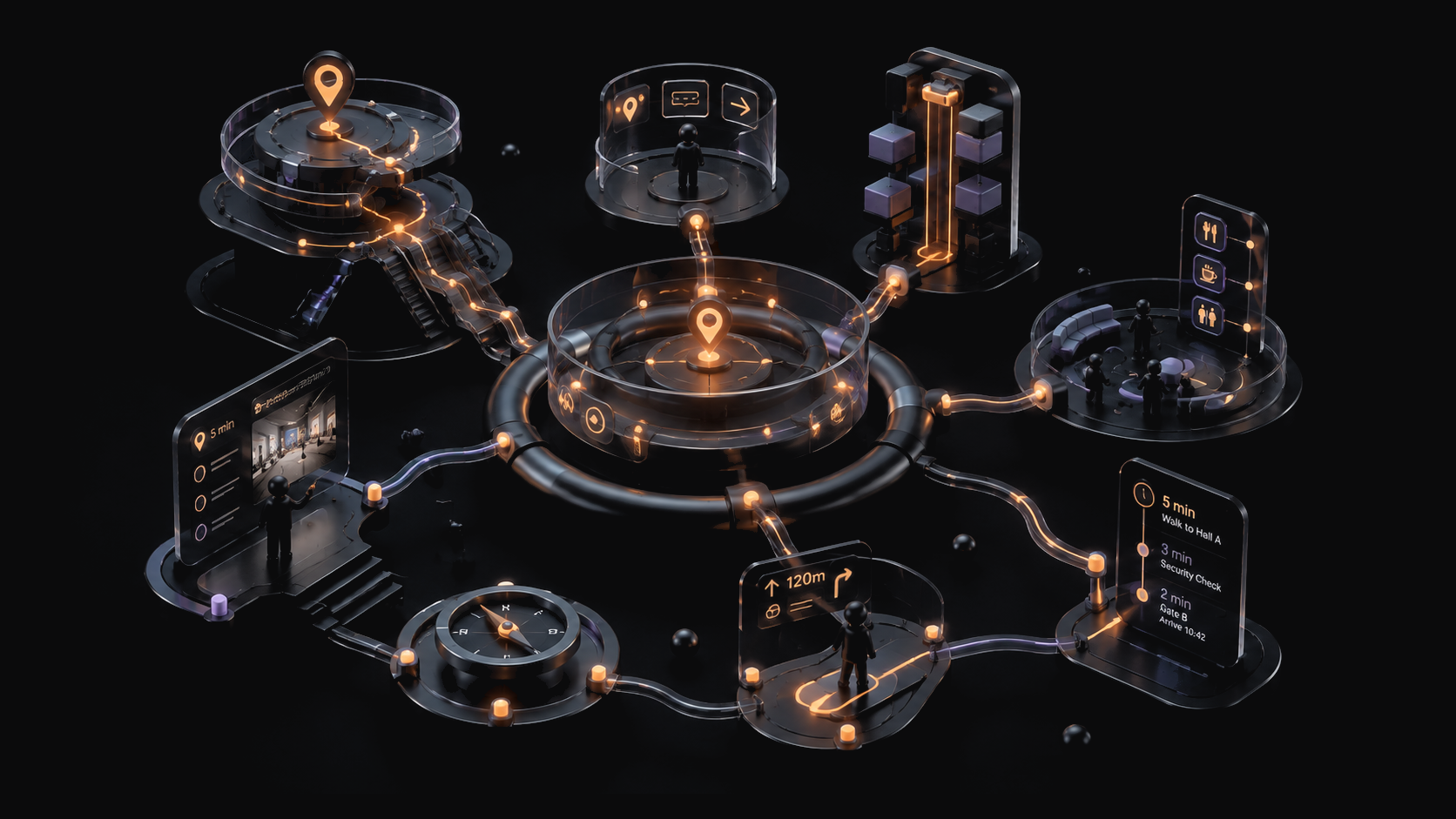
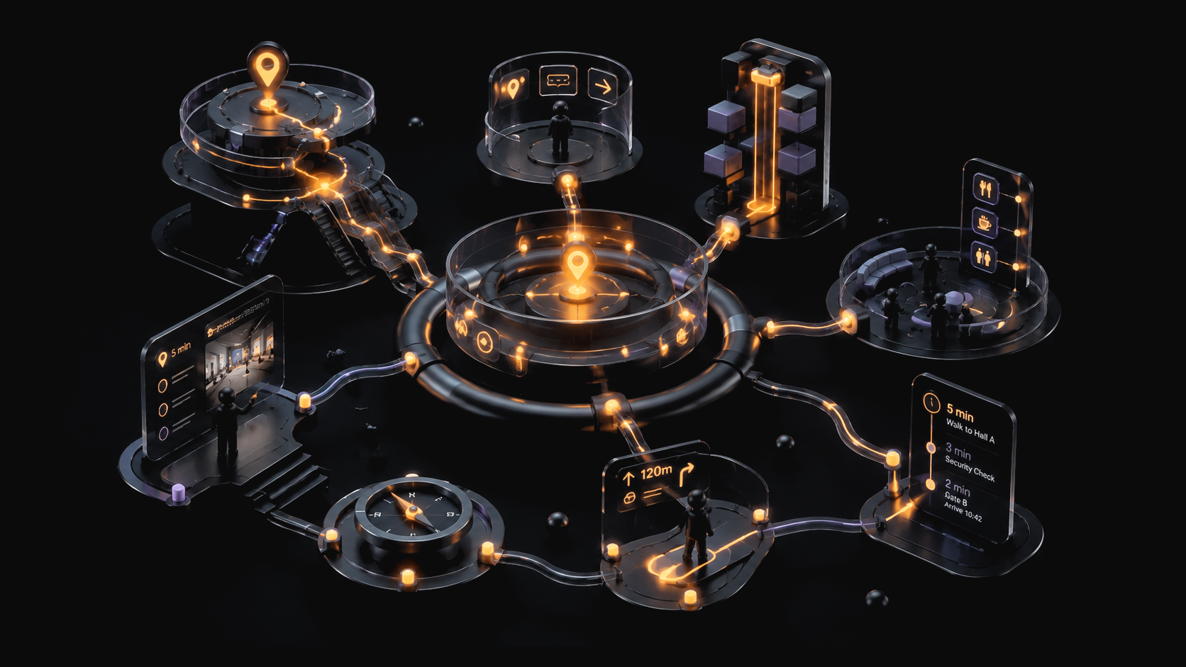
NaviXR is being defined as a modular system connecting mapped spaces, mobile AR guidance and contextual content, with spatial analytics treated as a planned capability until it is built and validated. The first step is one venue and one bounded navigation problem.
Large venues split navigation, interaction and operations into separate systems.
Visitors rely on signs, maps and staff to find their way. Interactive experiences are often temporary layers with separate technology. Operators receive little shared context about movement, friction and participation. Each part may work alone while the venue remains difficult to understand as one system.
The venue becomes a mapped environment with one interaction layer.
NaviXR begins with venue mapping. The mapped space is intended to support mobile AR directions and contextual overlays. Planned motion-based interactions add activities or challenges, while a later analytics layer may give operators a view of flow and engagement.
Participants
System outcomes
Connected modules
- 01Venue mapping
AR-ready spatial structure for routes and points of interest
- 02AR navigation
Planned mobile guidance and contextual overlays
- 03Motion interaction
Planned pose-based activities and engagement mechanics
- 04Experience layer
Challenges, prompts and immersive content
- 05Spatial analytics
Planned visibility into flow, activity and engagement
- 01Map
Convert one venue area into an AR-ready spatial model.
- 02Configure
Set routes, destinations and contextual content.
- 03Guide
Let visitors follow mobile AR directions.
- 04Activate
Add planned interaction to the same spatial layer.
- 05Review
Use agreed signals to refine the next venue cycle.
Feedback loopThe mapped infrastructure may support the next route or activation. Reuse remains a hypothesis until one venue is built and operated.
The first artifact is one mapped route, not an Expo-scale platform.
The current product definition includes a core architecture, planned experience and intended Expo-scale validation context. It does not yet include a completed venue map, working visitor route or live analytics. The first build should reduce the concept to one place, one route and one operating question.
- 01 / MapAR spatial preparationImplementation teams
One route and its points of interest gain a reusable digital structure.
- 02 / ConfigureRoute and destination modelVenue operators
The pilot has a defined origin, destination and operating purpose.
- 03 / GuideMobile AR navigationVisitors
Directional guidance can be tested inside the physical context.
- 04 / ActivateContextual interactionExperience teams
One prompt or activity can be attached to the mapped route.
- 05 / ReviewEvidence definitionVenue operators
The partner can agree which usability and operating signals matter before collection.
First prototype scope
Next artifactMapped visitor route
The artifact is specified but no working venue deployment is documented.
- One bounded venue area with accurate route geometry
- One visitor origin, destination and mobile guidance flow
- One contextual content or interaction point
- Device, accessibility, safety and evidence review before visitor testing
- 01
Starting belief
Navigation can become the shared spatial foundation.
The product thesis links visitor guidance, interactive content and operating signals through one mapped environment.
Final NaviXR project source - 02
Documented frame
The architecture is defined, but no mapped environment is evidenced.
Navigation, motion interaction and analytics are defined as connected layers. A working route and visitor use are not yet evidenced.
Final project landing-page specification - 03
Scope decision
One useful route should come before platform breadth.
A bounded deployment can test mapping, mobile guidance and venue operation before motion or analytics claims expand.
Current validation direction - 04
Next evidence
Map one real environment with an accountable operator.
The concept advances when visitors can follow a defined route and the venue can review usability and operational reliability.
Required first deployment
One spatial system creates different value for visitors, operators and experience partners.
Visitors
- Guidance inside the physical environment
- Contextual content at relevant locations
- One route from finding a place to interacting with it
Venue operators
- A reusable mapping and route layer
- Potential visibility into agreed movement and engagement signals
- Less fragmentation between visitor-facing systems
Experience partners
- A shared foundation for more than one activation
- Room for event, museum and public-space use cases
- A deployment model that can be tested one venue at a time
The venue contexts are named. Demand, deployment cost and commercial terms are not.
NaviXR is intended for events, museums, sports venues, smart-city programs and public environments. The product has a reusable infrastructure direction and an intended Expo-scale setting, but no sourced market size, customer commitment, deployment cost, price, revenue or operating result is currently claimed.
- DefinedCore architecture
- Final NaviXR project source
- Navigation, interaction and planned analytics share one documented system model.
- MappedRequired venue input
- Final NaviXR workflow
- Every useful validation begins with accurate spatial preparation.
- Expo-scaleIntended first environment
- Final NaviXR project source
- This is a planned context, not evidence of a confirmed or completed deployment.
- No live dataCurrent evidence constraint
- Local website materials
- Navigation fit, operating value and spatial analytics remain hypotheses.
- Primary buyers
- Venue and public-environment operators
Event organizers, museums, sports venues, smart-city programs and public-space operators are named as target settings.
defined - Delivery model
- Venue-specific mapping and configuration
Each implementation begins with a physical environment, route model and content configuration.
defined - Revenue model
- Not specified in current materials
Platform licence, implementation, content and support responsibilities still need commercial definition.
open - Pricing and economics
- To be tested in the first mapped environment
Deployment cost, working price, procurement cycle and reuse economics still need validation.
open - Funding path
- Pre-seed first deployment
Early funding is intended to support mapping, the visitor flow and the first validation cycle.
planned
The concept advances when a visitor can follow one route and the venue can operate it.
Validation gate
One mapped route works in a real venue under an accountable operator.
Gate not yet passedWhat must be true
- to agreeSpatial reliability
The mapped route and points of interest remain accurate enough for the agreed visitor flow.
- to agreeVisitor usability
Participants can open and follow the mobile guidance on the agreed devices without staff repairing the route.
- openOperational fit
The venue can configure, monitor and maintain the route within an agreed operating process.
- openResponsible measurement
Accessibility, privacy, safety and analytics boundaries are agreed before visitor signals are collected.
SKWD can build the spatial layer. The partner must bring the first real place.
SKWD carries in
- The documented mapping, navigation, interaction and analytics architecture
- XR product and content-delivery capability
- An evidence boundary between planned intelligence and observed venue use
This venture adds
- One mapped route and mobile AR guidance flow
- One contextual visitor interaction
- The operator controls and evidence model for the first deployment
External proof needed
- A venue with a real navigation problem and bounded pilot area
- An accountable operator and implementation owner
- Visitor access plus accessibility, safety and privacy review
Next step
Choose one venue and define the first mapped route.
Bring a physical environment, operating problem and visitor use case. We will agree the artifact and validation gate before treating the platform as deployment-ready.
NaviXR is a concept in development. AR navigation, motion analysis and spatial analytics describe the planned architecture. They do not demonstrate a completed venue deployment, real-time operating performance or measured visitor outcomes.